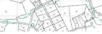
Tax maps are simply maps that show the boundary lines between individually owned properties. They may also be called parcel maps, or cadastral maps.
Tax maps are intended to be a visual inventory of all real property within the jurisdiction, for the sole purpose of administering property tax assessment. In Berks County, they are also used to assign a Parcel Identification Number (PIN), and calculate an assessed acreage for each tract.
Tax maps are of utility to many different users. They are a valuable tool for surveyors, title searchers, realtors, appraisers, lawyers, developers, various other business people, other government jurisdictions, taxpayers, and the just plain curious. If you want to know who owns a property, tax maps are often one of the first places to look.
Click here to access the tax maps. Be aware that if the property you are interested in spans two or more map sheets, you will need more than one copy to show the entire property.
1409 standard tax maps to cover all of Berks County.
Property deeds contain a paragraph called the legal description, which is text that describes the boundary of the property. The legal description usually contains courses known as metes and bounds, or bearings and distances, such as North 45 degrees 50 minutes 32 seconds West, 591.44 feet. The bearings and distances are plotted out to produce an outline of the property. The outlines of all of the properties are put together like a jigsaw puzzle, to create the tax map. The work of making the maps is done on computers, and the finished maps are then plotted onto paper.
Berks County is a growing county. Every year there are hundreds of new lots due to subdivisions. When a farm field becomes a residential development, the tax maps must reflect the new lot lines. Also, tax maps change when corrections are necessary.
The frequency and volume of property ownership changes precludes showing that information on hard copy maps.
The tax maps are like a jigsaw puzzle in which the pieces do not fit together with one another. The tax maps are a graphic representation of the information in deeds, survey plans, and other primary sources of information. In many cases, the data sources have deficiencies or conflicts that caused the map to be incorrect. If new information surfaces, or if there is a new survey or subdivision, adjoining properties may be adjusted on the map. And, it’s possible that the previous mapper just made a mistake that must be fixed. So no, the map will never be ‘right’ or ‘finished’.
An acreage is necessary to calculate land value. Many deeds do not state the area. Some other deeds have incorrect area, due to typographical error or an error in calculation. And, many deeds include area that falls within the public street right of way, which we do not count for tax assessment. Indeed, it is more likely that the deed acreage and map acreage will be different, rather than the same.
Your deed is the legal evidence of what you own, not the tax map. The map acreage represents only the amount of land that you are being assessed for. The difference may actually be to your financial advantage, if the amount of difference is great enough to lower your assessment calculation. However, if the difference is large, we would like to be informed, to check whether a map correction is necessary. If the acreage difference is significant, and we decline to change the tax map, you may wish to get a property survey, which is the only true way to determine exactly how much land you own.
Let us know. If a map correction is in order, we will make it. Bear in mind, that the deed may be in error, rather than the map. In addition, if the difference is very small, it will not lower your assessment. If the difference is significant, and we can not justify a map correction, a property survey will determine exactly how much land you own.
The tax maps are not legal evidence of size, shape, location, ownership, or boundary of real property, public rights of way, or municipal boundary lines. Only a surveyor can determine your boundary. If, after your surveyor determines the boundary, your neighbor still refuses to acknowledge it, you then need the service of a lawyer. If both parties have conflicting surveys and their respective surveyors and lawyers will not agree, then ultimately the boundary will be determined in civil court.


